Welcome to PipeTrack
A revolution in pipeline, culvert & tunnel mapping
Introduced in 2006, the new PipeTrack equipment utilises gyro-based surveying technology that enables the mapping of both existing and new pipelines constructed of any currently used material.
Infotec now provide clients with the most advanced range of specialist surveying systems available anywhere in the world. The combination of PipeTrack Gyroscopic Mapping, advanced autonomous Robots and ROV mobilisation systems along with in-built "LIDAR" Laser Scanning systems enable us to provide a full 3D survey of any type or size of structure.
By producing a definitive record of any surveyed structure, we can as part of any subsequent survey highlight minute changes including changes of profile caused by deformation. Identify new structural defects or determine the extent of deterioration. This is now achieved using advanced change recognition software, eliminating any risk of human error.
A major advantage of the PipeTrack system is that, unlike most of the technologies currently used in buried service mapping operations; it is not affected by any electromagnetic field that may be generated by nearby existing buried utilities, such as power carrying cables etc.
![]()
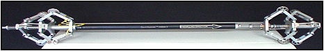
The PipeTrack Concept
Originally developed in Belgium to map newly constructed HDD bores, the new PipeTrack concept offers accurate, simple and flexible 3D mapping of a pipeline providing pinpoint data of not just its route in plan view but also its depth and longitudinal alignment. A vital consideration given current thinking on asset management and remediation of utilities.
The system is designed to complement more conventional and traditional pipeline locating technologies. The unit is very easy to use and requires no tracing or tethering or umbilical connection to the surface during survey and yet gives the precise 'centreline' position of the pipeline surveyed.
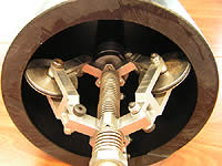
The scalable design of the PipeTrack enables it to be used in pipelines from as small as 50mm diameter up to 2.5m diameter. The unit can also handle a variety of pipe bend radii depending on the pipe diameter being surveyed. At a pipe i.d. of 90mm the maximum bend radius is 4.5m whilst in a 300mm diameter pipe the bend radius will be 0.9m.
Further developments will include the articulation of the unit, allowing it to negotiate oven more acute bends and radii. For longer diameter pipes, culverts or tunnels even greater accuracy will be achievable.
Using the PipeTrack unit, a trained team has the capability to map up to 500m of pipeline in a single stretch in less than one hour, including set-up and breakdown time. This capacity ensures both minimum interruption to pipeline services and consumer downtime.
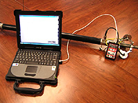
The PipeTrack unit records data autonomously using an on-board storage system and therefore has no restrictions on depth of working or length of survey achievable. Accurate and rapid data storage is achieved using the patented X-Traction™ data processing software.
 |
 |
| "Compared to the cost of conventional gyro mapping tools and services, the PipeTrack system will provide significant direct and indirect cost savings and will set a new standard in asset management and network maintenance. The PipeTrack system will also take current underground service mapping capabilities and our understanding of the location and interaction of existing buried networks to a standard not yet achieved in the UK." David Pitt, Managing Director of Infotec |
-- top of page --